
Green Swamp, NC Maps
(3 maps)

The yellow lines are a rough outline of the original Green
Swamp area based on the Brunswick County Green Swamp Area Map.
The red lines are current protected areas within the Green Swamp. The
line are drawn on a photo of Google maps. You can see
the development within the yellow lines: farms, tree farms, roads, and
canals.

Brunswick
County Map of the original boundaries of the Green Swamp

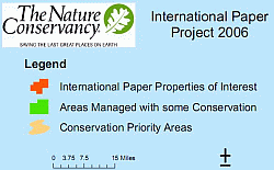 This map
shows areas under some conservation protection and areas the
This map
shows areas under some conservation protection and areas the
Nature Conservancy are interested in protecting.
©
2005 Orchid Conservation Coalition. All logos are trademarks of the
Orchid Conservation Coalition.